Computer Simulation System CIS-KOSMAS�
Purpose
Computer simulation system CIS-KOSMAS� is intended for examination, studying and projecting of development of city emergency services.
General description of simulation system
Generally speaking, CIS-KOSMAS� is a complex set of mathematical models using probabilistic-statistical regularities in operations of an emergency service and topographic parameters of the territory where this service operates.
In computer terms, it is a software product which combines a set of computer programs into a single system, reproducing algorithms that consistently describe (simulate) all details of the process of an emergency service operation. Figure 1 represents a general structure of the simulation system KOSMAS.
The simulation system is designed to investigate the process of municipal emergency services� operations and to provide expert evaluation of project, organizational and management decisions related to the activities of these services.
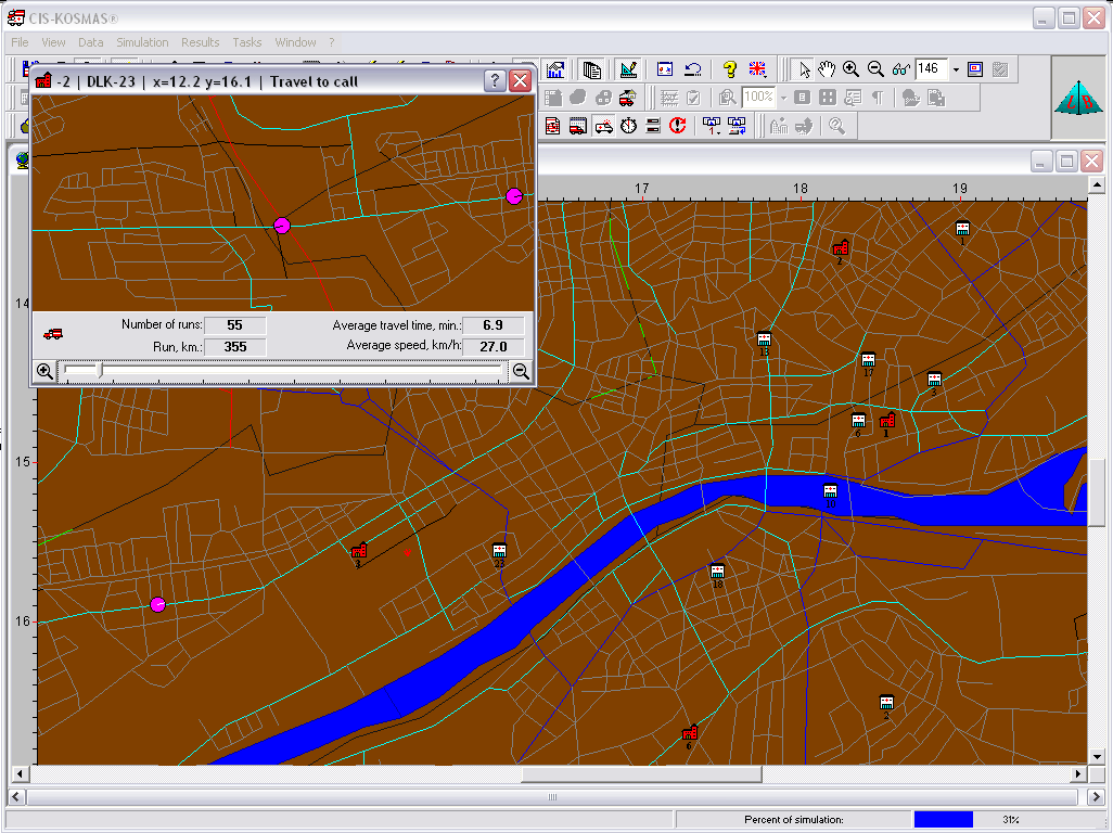
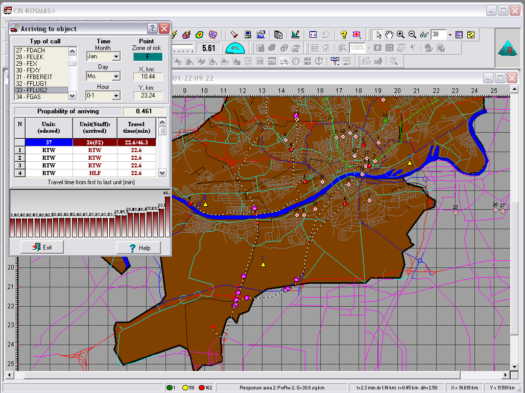
In the simulation KOSMAS system a city (a territory) is represented in the form of a graph showing a street grid and a continuous space of a given configuration, indicating locations of various municipal objects, hospitals, emergency service stations, their response areas, equipment and personnel stationed in each facility, etc. A street grid in the system is represented in the form of �vectors�. Each section can be assigned its own traffic speed (the speed can change depending on the time of day) and traffic direction. The Deixtra�s algorithm is used as a basic algorithm to search for optimal routes.
At the core of the computer system there are simulation models based on statistical regularities of random processes inherent in the municipal emergency services� operations.
Generally speaking, a simulation model is a computer program which describes in terms of a programming language and with varying level of detail all those processes, actions and events (in accordance with the operations of a specific emergency service), which occur after the moment a call comes through to the central switchboard of a municipal emergency service and until the moment the emergency units return back to their stations.
In the model this course of events is determined by a modeling algorithm, which, when it is run on a computer by means of arithmetic and logical operations, reproduces the processes which occur in the system under investigation, maintaining key time and quantitative correlations.
In order to model various time characteristics the model deploys real time statistical distributions that are typical for a city (territory) under investigation.
For example, the Poisson distribution in applied in order to model the time at which emergency calls are received.
In order to model other time characteristics (the time during which emergency units are dispatched, collected and respond to a call, the time during which they are occupied at a call site, the time during which they are employed in hospitals, etc.), the Erlangian distribution is applied of this or that degree, or some other statistical distributions.
The time spent by emergency service units traveling to a call site are determined in the model based on direct modeling of traffic flows in the city�s street grid, taking into account speed characteristics of vehicles and the city�s transportation grid.
In order to model the time during which emergency units are occupied at a call site, the Erlangian distribution is applied of the 0-degree or already existing models of fire development and extinguishing, rescue operations� models, etc., can be applied.
Through the process of simulation experiments KOSMAS can solve a very wide range of practically significant tasks. Thus, for example, by varying system parameters (fire stations, their location sites, boundaries of response areas, traffic control options, speed of automobile traffic in various parts of the city, density of call flows for the city overall and for its specific districts, etc.), one can obtain any characteristics of the processes of emergency services� operations and select the most rational and cost-effective options for their organizational structures.
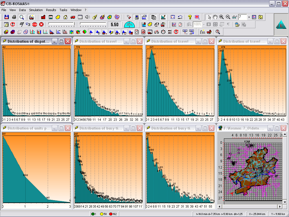
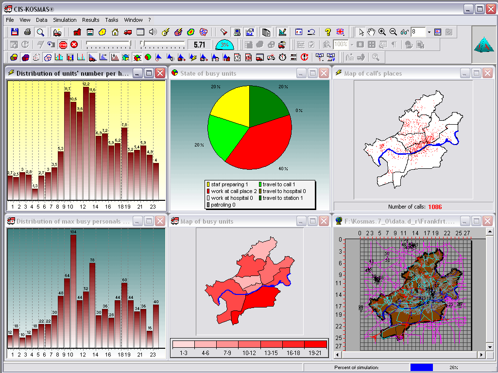
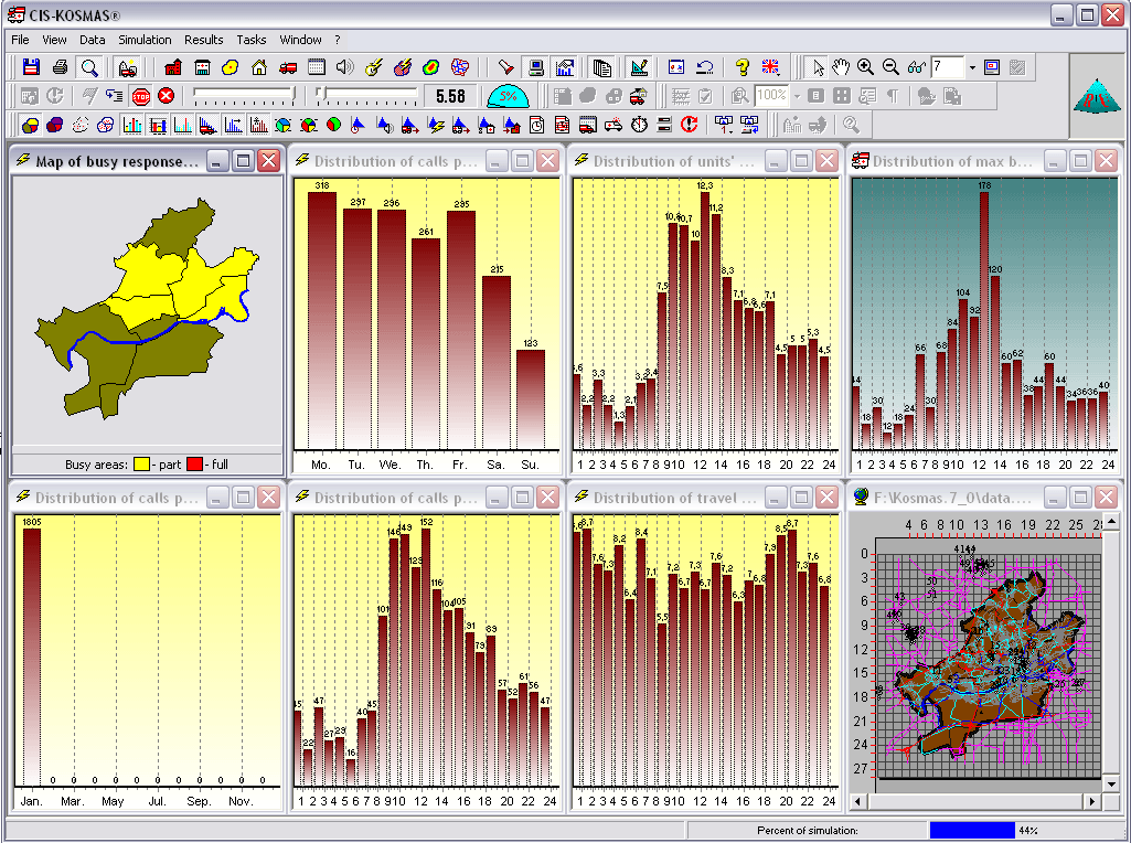
It is extremely important that in the course of conducting simulation experiments a user is able to monitor (to control) the whole simulation process on the computer�s screen. This refers to call distribution in the city�s territory, traffic of emergency units through the city�s territory, all kinds of informational maps, diagrams and tables which characterize the process of emergency service operations. Thus, researchers (as well as all the interested parties � emergency service managers and city administration) are able to see the impact that changes in certain initial parameters have on the process of service operations.
KOSMAS is designed to give answers to such questions as - what will happen to the city if: we close down some of the fire stations or, on the contrary, if we build several new fire stations? What if we change the boundaries of response areas? What if we remove (or add) several mobile units (on engines, on ladders, on ambulance vehicles, etc.)? and what if we change the personnel headcount and their duty roster? Or will emergency units be able to reach a certain urban object in the required number and within a certain period of time in case an emergency situation develops on this object? � as well as to many other similar questions.
A mandatory requirement imposed on any mathematical model of any process is its adequacy to reality, i.e. the description of the real life process must be exact enough, so that this model could be used in practice.
The test of a model�s adequacy is a mandatory condition for system�s adaptation to a specific emergency service. Based on the experience of deploying the simulation model, one can state that it demonstrates very good parameters in terms of stability of modeling results and adequacy. In terms of key modeled distributions (distribution of calls in time and space, by call types, distribution of various time characteristics of emergency units� operations) the variances between the real life data and modeling results is 6 -7 % at the most.
Capabilities of the system
Below you can see the main capabilities provided to a user by the simulation system.
The system enables:
|
|
Entering and changing any input data characterizing city parameters, emergency service and operating environment in the city; |
|
|
Modeling various real-life and hypothetic situations, which occur or can occur in the city when the parameters of the city environment, emergency service or operating situation change; |
|
|
Visualizing the modeling process providing various pieces of information that characterize it; |
|
|
Solving optimization tasks (for specific conditions), using various criteria с (e.g. average of maximum time for arrival of the first or the last emergency unit to the call site, uniformity of workload on each emergency unit, etc.) with respect to determining locations of new fire stations, hospitals, distributing equipment among facilities, identifying traffic control options, establishing duty rosters for personnel, etc.); |
|
|
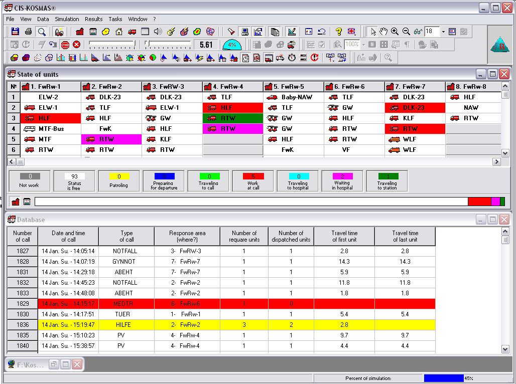
Building a data base (for further processing) as simulation goes on, containing the parameters characterizing the operating process of each emergency unit; |
|
|
Automating performance of simulation experiments. The simulation system provides for over 50 forms of pre-configured reports; |
|
|
Determining time and probabilistic characteristics of emergency units� response to situations of various levels of complexity which occur at urban objects; |
|
|
Investigating various options for emergency units� patrolling a city; |
|
|
Investigating and comparing various options for traffic control of emergency units; |
|
|
Analyzing statistical data accumulated in the course of the modeling process; |
|
|
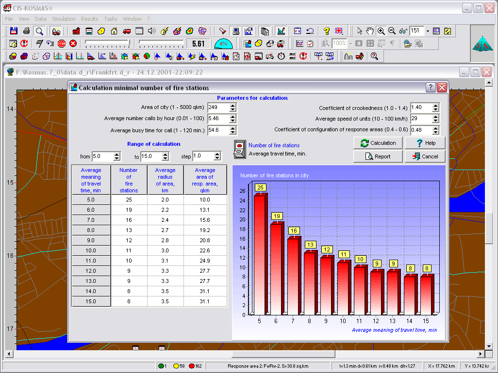
Calculating the number of fire houses depending on the emergency units� response time. |
|
|
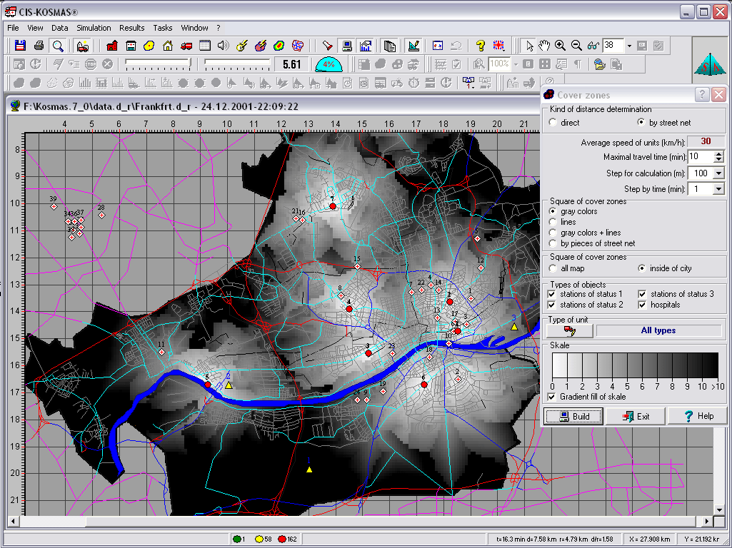
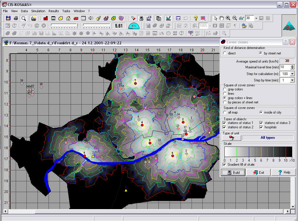
Determining a city�s response areas of emergency units depending on their response time; |
|
|
Determining the optimal boundaries of response areas of emergency units; |
|
|
Determining the required number of emergency units of different types; |
|
|
Analyzing risk zones of the city territory; |
|
|
Obtaining help in the process of working with the system. |
|
|
etc. |
Adaptation of system
The process of adapting the simulation system for expert analysis and development projects of restructuring this or that emergency service in a specific city consists of the following stages:
-
collecting information characterizing the territory (configuration of city and city�s districts, street grid, characteristic and location of city�s objects, etc.);
-
emergency service (parameters and location of stations and hospitals, types and parameters of emergency units, allocation emergency units by stations, rules on who will respond to emergency calls from which locations, etc.). Mostly using data bases of aid dispatcher systems, traffic control services and data from geographic information systems;
-
analyzing probabilistic and statistical regularities of the process of emergency service operations: distributions of calls by types, distributions of each type of call by time (by mounts, by days of week, by hours of day) and by territory of city (by city�s districts and other territorial units), distributions of different temporal parameters etc.
-
processing the baseline data (aligning them with the system requirements) and enter data in system;
-
validating adequacy of the modeling results and testing the system;
-
commissioning the system into production, training users to work with the system.
The system is open to modernization, which is why any specifics related to the activities of a certain service or to a territory can be additionally taken into account and added to the system at the adaptation stage.
Duration of adaptation
Ordinary (without modernization) adaptation of the simulation system duration to a specific emergency service of a city (or of a territory) on average takes 6 to 8 months. Training of the system user�s personnel lasts 6 to 7 days.
Technical requirements
The technical requirements to hardware are as follows: an IBM-compatible personal computer, with processor 1 GHz or better, random access memory should not be than 1 Gb, the required memory capacity of the hard disk should not be less than 500 Mb, operation system MS Windows XP, Vista, 7, or latest.
Field of application
|
|
Fire and rescue services |
|
|
Police |
|
|
Ambulance |
|
|
Other emergency services |
Main input data
|
|
Map of area (files of map in format of geographical information systems ArcView (*.SHP), MapInfo (*.MIF)) |
|
|
Parameters of emergency service (data base of emergency services) |
|
|
Statistical data of emergency services activities (data base of emergency services) |